
San Andrés Tuxtla topographic map
Interactive map
Click on the map to display elevation.
About this map
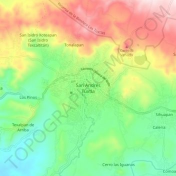
Name: San Andrés Tuxtla topographic map, elevation, terrain.
Location: San Andrés Tuxtla, Veracruz, 95700, México (18.40587 -95.25346 18.48587 -95.17346)
Average elevation: 346 m
Minimum elevation: 110 m
Maximum elevation: 701 m
Other topographic maps
Click on a map to view its topography, its elevation and its terrain.
Calería
México > Veracruz > San Andrés Tuxtla > Calería
Calería, San Andrés Tuxtla, Veracruz, 95700, México
Average elevation: 261 m