
Fraissinet-de-Fourques topographic map
Interactive map
Click on the map to display elevation.
About this map
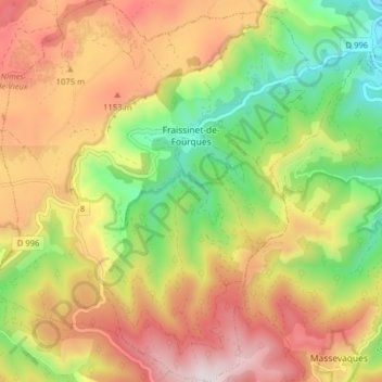
Name: Fraissinet-de-Fourques topographic map, elevation, terrain.
Average elevation: 985 m
Minimum elevation: 643 m
Maximum elevation: 1,341 m
Other topographic maps
Click on a map to view its topography, its elevation and its terrain.
Col de Perjuret
France > Occitanie > Fraissinet-de-Fourques
Col de Perjuret, D 18, Malbosc, Fraissinet-de-Fourques, Florac, Lozère, Occitanie, France métropolitaine, 48400, France
Average elevation: 980 m