
Thank you for supporting this site ❤️
Make a donation
Make a donation
Muntilan topographic map
Click on the map to display elevation.
Thank you for supporting this site ❤️
Make a donation
Make a donation
About this map
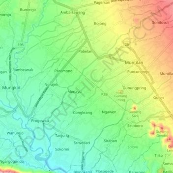
Name: Muntilan topographic map, elevation, terrain.
Location: Muntilan, Magelang, Central Java, Java, 56451, Indonesia (-7.63517 110.23631 -7.54755 110.30666)
Average elevation: 296 m
Minimum elevation: 198 m
Maximum elevation: 495 m
Thank you for supporting this site ❤️
Make a donation
Make a donation
Other topographic maps
Click on a map to view its topography, its elevation and its terrain.
Thank you for supporting this site ❤️
Make a donation
Make a donation
Lapangan Paripurno Kecamatan Salaman
Indonesia > Central Java > Magelang > Kembanglimus
Average elevation: 276 m
Thank you for supporting this site ❤️
Make a donation
Make a donation
Thank you for supporting this site ❤️
Make a donation
Make a donation
Thank you for supporting this site ❤️
Make a donation
Make a donation