
Thank you for supporting this site ❤️
Make a donation
Make a donation
Riva topographic map
Click on the map to display elevation.
Thank you for supporting this site ❤️
Make a donation
Make a donation
About this map
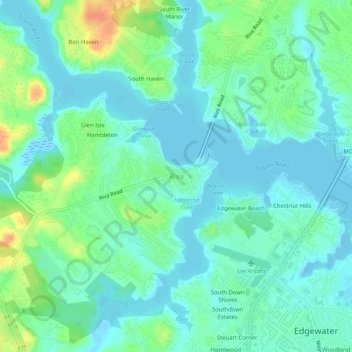
Name: Riva topographic map, elevation, terrain.
Location: Riva, Anne Arundel County, Maryland, 21041, United States (38.93206 -76.59802 38.97206 -76.55802)
Average elevation: 11 m
Minimum elevation: -4 m
Maximum elevation: 40 m
Thank you for supporting this site ❤️
Make a donation
Make a donation
Other topographic maps
Click on a map to view its topography, its elevation and its terrain.
Pasadena
United States > Maryland > Anne Arundel County > Pasadena
Pasadena is located at 39°6′46″N 76°33′7″W / 39.11278°N 76.55194°W / 39.11278; -76.55194 (39.112809, −76.551871) in northern Anne Arundel County. It is bordered to the north by the city of Baltimore, to the east by the tidal Patapsco River and by Riviera Beach, to the southeast by Lake…
Average elevation: 13 m
Thank you for supporting this site ❤️
Make a donation
Make a donation
Thank you for supporting this site ❤️
Make a donation
Make a donation