
Praag topographic map
Interactive map
Click on the map to display elevation.
About this map
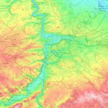
Name: Praag topographic map, elevation, terrain.
Location: Praag, Praha, Tsjechië (49.94190 14.22444 50.17743 14.70679)
Average elevation: 300 m
Minimum elevation: 167 m
Maximum elevation: 508 m
Ook het Dansende Huis is een gebouw dat opvalt. Niet vanwege zijn hoogte, maar vanwege de deconstructivistische bouwstijl. Het gebouw staat aan de Moldau en werd geopend in 1996.
Other topographic maps
Click on a map to view its topography, its elevation and its terrain.