
Thank you for supporting this site ❤️
Make a donation
Make a donation
Blarney topographic map
Click on the map to display elevation.
Thank you for supporting this site ❤️
Make a donation
Make a donation
About this map
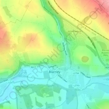
Name: Blarney topographic map, elevation, terrain.
Location: Blarney, County Cork, Munster, Ireland (51.92799 -8.57760 51.94590 -8.55471)
Average elevation: 64 m
Minimum elevation: 22 m
Maximum elevation: 131 m
Thank you for supporting this site ❤️
Make a donation
Make a donation
Other topographic maps
Click on a map to view its topography, its elevation and its terrain.