
Confluence topographic map
Interactive map
Click on the map to display elevation.
About this map
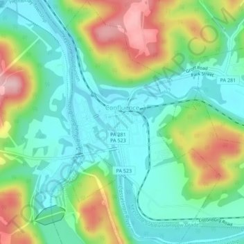
Name: Confluence topographic map, elevation, terrain.
Location: Confluence, Somerset County, Pennsylvania, United States (39.79463 -79.36717 39.82716 -79.33959)
Average elevation: 459 m
Minimum elevation: 393 m
Maximum elevation: 593 m
Other topographic maps
Click on a map to view its topography, its elevation and its terrain.
Hooversville
United States > Pennsylvania > Somerset County
Hooversville, Somerset County, Pennsylvania, United States
Average elevation: 579 m
Mount Davis
United States > Pennsylvania > Somerset County > Elk Lick Township
Mount Davis, Elk Lick Township, Somerset County, Pennsylvania, 15540, United States
Average elevation: 908 m