
La Urz topographic map
Interactive map
Click on the map to display elevation.
About this map
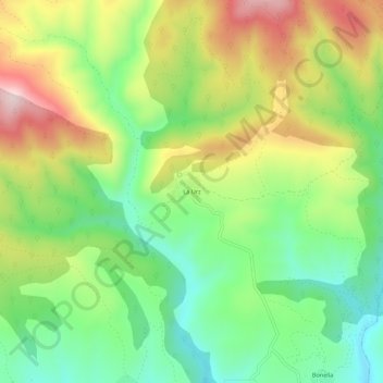
Name: La Urz topographic map, elevation, terrain.
Location: La Urz, Riello, León, Castilla y León, 24127, España (42.79714 -5.97257 42.83714 -5.93257)
Average elevation: 1,236 m
Minimum elevation: 1,074 m
Maximum elevation: 1,466 m
Está situada a media ladera, a una altitud de 1220 m por encima del valle del arroyo Curueña. Las poblaciones más cercanas son Bonella y Socil al sur, Curueña al norte, y Villarín de Riello y Robledo de Omaña al oeste.
Other topographic maps
Click on a map to view its topography, its elevation and its terrain.
Peña del Palomar
España > Castilla y León > Riello
Peña del Palomar, Riello, León, Castilla y León, España
Average elevation: 1,569 m
Villarubia
España > Castilla y León > Riello > Manzaneda de Omaña
Villarubia, Manzaneda de Omaña, Riello, León, Castilla y León, España
Average elevation: 1,256 m
Piedra Hincada
España > Castilla y León > Riello
Piedra Hincada, Riello, León, Castilla y León, España
Average elevation: 1,564 m