
Schleswig-Holstein topographic map
Interactive map
Click on the map to display elevation.
Schleswig-Holstein
The Baltic Sea coast in the east of Schleswig-Holstein is marked by bays, fjords, and cliff lines. Rolling hills (the highest elevation is the Bungsberg at 168 metres or 551 feet) and many lakes are found, especially in the eastern part of Holstein called the Holstein Switzerland and the former Duchy of Lauenburg (Herzogtum Lauenburg). The longest river besides the Elbe is the Eider.
About this map
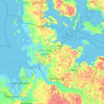
Name: Schleswig-Holstein topographic map, elevation, terrain.
Location: Schleswig-Holstein, Germany (53.35981 7.52116 55.09916 11.67239)
Average elevation: 17 m
Minimum elevation: -6 m
Maximum elevation: 160 m
Other topographic maps
Click on a map to view its topography, its elevation and its terrain.
Zugspitze
Germany > Bavaria > Landkreis Garmisch-Partenkirchen > Grainau
The mountain rises eleven kilometres southwest of Garmisch-Partenkirchen and just under six kilometres east of Ehrwald. The border between Germany and Austria runs over the west summit; thus the Zugspitze massif belongs to the German state of Bavaria and the Austrian state of Tyrol. The municipalities…
Average elevation: 2,300 m
UNESCO Weltnaturerbe Grube Messel
Germany > Hesse > Landkreis Darmstadt-Dieburg > Messel
Average elevation: 171 m
Bend
Germany > North Rhine-Westphalia > Städteregion Aachen > Stolberg > Schevenhütte
Average elevation: 267 m
Relling
Germany > Baden-Württemberg > Landkreis Ludwigsburg > Freiberg am Neckar
Average elevation: 257 m
Bochum
Germany > North Rhine-Westphalia > Bochum
The city lies on the low rolling hills of Bochum land ridge (Bochumer Landrücken), part of the Ruhrhöhen (highest elevations) between the Ruhr and Emscher rivers at the border of the southern and northern Ruhr coal region. The highest point of the city is at Kemnader Straße (Kemnader Street) in Stiepel at…
Average elevation: 107 m