
Thank you for supporting this site ❤️
Make a donation
Make a donation
Tønder Kommune topographic map
Click on the map to display elevation.
Thank you for supporting this site ❤️
Make a donation
Make a donation
About this map
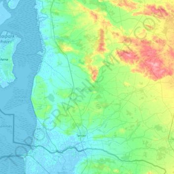
Name: Tønder Kommune topographic map, elevation, terrain.
Location: Tønder Kommune, Danemark-du-Sud, Danemark (54.88151 8.46342 55.24471 9.24965)
Average elevation: 16 m
Minimum elevation: -5 m
Maximum elevation: 82 m
Thank you for supporting this site ❤️
Make a donation
Make a donation
Other topographic maps
Click on a map to view its topography, its elevation and its terrain.