
Thank you for supporting this site ❤️
Make a donation
Make a donation
Moti Island topographic map
Click on the map to display elevation.
Thank you for supporting this site ❤️
Make a donation
Make a donation
About this map
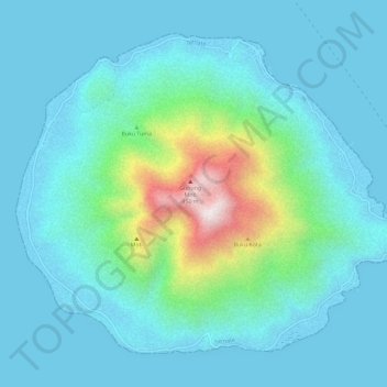
Name: Moti Island topographic map, elevation, terrain.
Location: Moti Island, Ternate, North Maluku, Indonesia (0.43272 127.38186 0.48075 127.43990)
Average elevation: 146 m
Minimum elevation: -1 m
Maximum elevation: 918 m
Thank you for supporting this site ❤️
Make a donation
Make a donation