
Thank you for supporting this site ❤️
Make a donation
Make a donation
San Manuel topographic map
Click on the map to display elevation.
Thank you for supporting this site ❤️
Make a donation
Make a donation
About this map
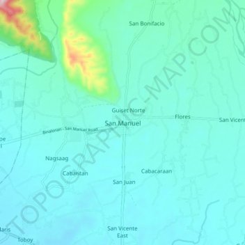
Name: San Manuel topographic map, elevation, terrain.
Location: San Manuel, Pangasinan, Ilocos Region, 2438, Philippines (16.02438 120.62818 16.10438 120.70818)
Average elevation: 76 m
Minimum elevation: 35 m
Maximum elevation: 361 m
Thank you for supporting this site ❤️
Make a donation
Make a donation
Other topographic maps
Click on a map to view its topography, its elevation and its terrain.