
Thank you for supporting this site ❤️
Make a donation
Make a donation
La Raya topographic map
Click on the map to display elevation.
Thank you for supporting this site ❤️
Make a donation
Make a donation
About this map
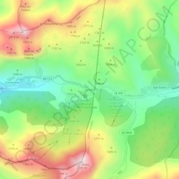
Name: La Raya topographic map, elevation, terrain.
Location: La Raya, El Pino, Aller, Astúrias, Espanha (43.04534 -5.40799 43.08534 -5.36799)
Average elevation: 1,647 m
Minimum elevation: 1,326 m
Maximum elevation: 2,076 m
Thank you for supporting this site ❤️
Make a donation
Make a donation
Other topographic maps
Click on a map to view its topography, its elevation and its terrain.