
Thank you for supporting this site ❤️
Make a donation
Make a donation
Jubrique topographic map
Click on the map to display elevation.
Thank you for supporting this site ❤️
Make a donation
Make a donation
About this map
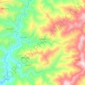
Name: Jubrique topographic map, elevation, terrain.
Location: Jubrique, Serranía de Ronda, Malaga, Andalusia, 29492, Spain (36.51864 -5.25671 36.60269 -5.16177)
Average elevation: 599 m
Minimum elevation: 138 m
Maximum elevation: 1,192 m
Thank you for supporting this site ❤️
Make a donation
Make a donation
Other topographic maps
Click on a map to view its topography, its elevation and its terrain.