
Thank you for supporting this site ❤️
Make a donation
Make a donation
Bantarwaru topographic map
Click on the map to display elevation.
Thank you for supporting this site ❤️
Make a donation
Make a donation
About this map
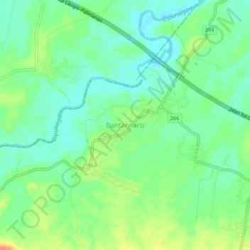
Name: Bantarwaru topographic map, elevation, terrain.
Location: Bantarwaru, Indramayu, West Java, Java, 41257, Indonesia (-6.58272 107.87037 -6.54272 107.91037)
Average elevation: 47 m
Minimum elevation: 29 m
Maximum elevation: 78 m
Thank you for supporting this site ❤️
Make a donation
Make a donation
Other topographic maps
Click on a map to view its topography, its elevation and its terrain.