
Carnoustie topographic map
Interactive map
Click on the map to display elevation.
About this map
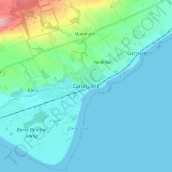
Name: Carnoustie topographic map, elevation, terrain.
Location: Carnoustie, Angus, Scotland, DD7 6AD, United Kingdom (56.46105 -2.75140 56.54105 -2.67140)
Average elevation: 24 m
Minimum elevation: 0 m
Maximum elevation: 168 m
Ultimately the origin of the name is unknown but predates the town itself by several hundred years. The earliest record is of "Carnowis" in a 1510 charter of James IV to Archibald Douglas, 5th Earl of Angus. 'Carnussie' farm is recorded in the Balmerino Abbey register of c. 1575, which states that it (along with part of Grange of Barry and Badiehill) was feued to the Fairny family and 'Karnousty' farm can be seen on Pont's map of Lower Angus, c. 1583––1596. The town is seen as 'Carnowstie' in a deed of sale from 1595, 'Carnushie' appears in a tax roll from Balmerino Abbey in 1617, and the lands of 'Carnouslie' are referred to in the title deeds confirming its purchase by George Maule, 2nd Earl of Panmure in 1672. Adair is perhaps the first to depict Carnoustie with the current spelling in 1703, while Roy's military survey of Scotland, 1747–55 has it as 'Cornisty'. In Webster's Topographical Dictionary of Scotland (1819), Carnoustie is mentioned as 'Carnuistie'.
Other topographic maps
Click on a map to view its topography, its elevation and its terrain.
Airlie
United Kingdom > Scotland > Angus
Airlie, Angus, Scotland, DD8 5HP, United Kingdom
Average elevation: 91 m
Aberlemno
United Kingdom > Scotland > Angus
Aberlemno, Angus, Scotland, DD8 3TE, United Kingdom
Average elevation: 114 m
Newtyle
United Kingdom > Scotland > Angus
Newtyle, Angus, Scotland, PH12 8TX, United Kingdom
Average elevation: 130 m
Barry
United Kingdom > Scotland > Angus
Barry, Angus, Scotland, DD7 7RF, United Kingdom
Average elevation: 22 m
Ashludie Farm
United Kingdom > Scotland > Angus > Monifieth
Ashludie Farm, Monifieth, Angus, Scotland, DD5 4JE, United Kingdom
Average elevation: 29 m
Inchbare
United Kingdom > Scotland > Angus
Inchbare, Angus, Scotland, DD9 7QJ, United Kingdom
Average elevation: 56 m
Brechin
United Kingdom > Scotland > Angus
Brechin, Angus, Scotland, DD9 6HH, United Kingdom
Average elevation: 71 m
Langley Park
United Kingdom > Scotland > Angus
Langley Park, Angus, Scotland, DD10 9LG, United Kingdom
Average elevation: 42 m
Glas Maol
United Kingdom > Scotland > Angus
Glas Maol, Angus, Scotland, AB35 5XU, United Kingdom
Average elevation: 869 m
Guthrie
United Kingdom > Scotland > Angus
Guthrie, Angus, Scotland, DD8 2TP, United Kingdom
Average elevation: 76 m
Driesh
United Kingdom > Scotland > Angus
Driesh, Angus, Scotland, DD8 4RD, United Kingdom
Average elevation: 705 m
Loch Brandy
United Kingdom > Scotland > Angus
Loch Brandy, Angus, Scotland, United Kingdom
Average elevation: 691 m
Montrose
United Kingdom > Scotland > Angus
Montrose, Angus, Scotland, DD10 8QW, United Kingdom
Average elevation: 22 m
Bridge of Dun
United Kingdom > Scotland > Angus
Bridge of Dun, Angus, Scotland, DD10 9LH, United Kingdom
Average elevation: 22 m
Inverkeilor
United Kingdom > Scotland > Angus
Inverkeilor, Angus, Scotland, DD11 5RN, United Kingdom
Average elevation: 40 m
Glen Lethnot
United Kingdom > Scotland > Angus
Glen Lethnot, Angus, Scotland, United Kingdom
Average elevation: 365 m
Arbroath
United Kingdom > Scotland > Angus
Arbroath, Angus, Scotland, DD11 1DP, United Kingdom
Average elevation: 24 m
Edzell Castle
United Kingdom > Scotland > Angus > Little Brechin
Edzell Castle, Edzell Castle Drive, Little Brechin, Angus, Scotland, DD9 7UE, United Kingdom
Average elevation: 98 m
Carlungie
United Kingdom > Scotland > Angus
Carlungie, Angus, Scotland, DD7 7SD, United Kingdom
Average elevation: 66 m
Tigerton
United Kingdom > Scotland > Angus
Tigerton, Angus, Scotland, DD9 7RL, United Kingdom
Average elevation: 147 m
Mains of Ardestie
United Kingdom > Scotland > Angus > Monifieth
Mains of Ardestie, Monifieth, Angus, Scotland, DD5 4HX, United Kingdom
Average elevation: 40 m
Brigton
United Kingdom > Scotland > Angus > Ruthven
Brigton, Ruthven, Angus, Scotland, PH12 8RG, United Kingdom
Average elevation: 67 m
Glen Doll
United Kingdom > Scotland > Angus
Glen Doll, Angus, Scotland, DD8 4RD, United Kingdom
Average elevation: 625 m
Birkhill
United Kingdom > Scotland > Angus
Birkhill, Angus, Scotland, DD2 5PY, United Kingdom
Average elevation: 118 m
Kirkbuddo
United Kingdom > Scotland > Angus
Kirkbuddo, Letham & District, Angus, Scotland, DD8 2NJ, United Kingdom
Average elevation: 159 m
Woodhill
United Kingdom > Scotland > Angus > Monifieth
Woodhill, Monifieth, Angus, Scotland, DD7 7SB, United Kingdom
Average elevation: 31 m
Little Brechin
United Kingdom > Scotland > Angus
Little Brechin, Angus, Scotland, DD9 6RQ, United Kingdom
Average elevation: 80 m
Finavon Castle
United Kingdom > Scotland > Angus > Milton of Finavon
Finavon Castle, Milton Lane, West Mains of Finavon, Milton of Finavon, Angus, Scotland, DD8 3PY, United Kingdom
Average elevation: 82 m
Glen Isla
United Kingdom > Scotland > Angus > Kirkton of Glenisla
Glen Isla, Kirkton of Glenisla, Angus, Scotland, PH11 8PH, United Kingdom
Average elevation: 430 m
South Ardo
United Kingdom > Scotland > Angus > Brechin > South Ardo
South Ardo, Brechin, Angus, Scotland, DD9 7PU, United Kingdom
Average elevation: 86 m
Forfar
United Kingdom > Scotland > Angus
Forfar, Angus, Scotland, United Kingdom
Average elevation: 95 m
Kirriemuir
United Kingdom > Scotland > Angus
Kirriemuir, Angus, Scotland, DD8 4EF, United Kingdom
Average elevation: 123 m
Langley Park Gardens
United Kingdom > Scotland > Angus > Langley Park
Langley Park Gardens, Langley Park, Angus, Scotland, United Kingdom
Average elevation: 36 m
Craichie
United Kingdom > Scotland > Angus > Craichie
Craichie, Angus, Scotland, DD8 2LU, United Kingdom
Average elevation: 121 m
South Craig
United Kingdom > Scotland > Angus
South Craig, Angus, Scotland, United Kingdom
Average elevation: 737 m
Glen Esk
United Kingdom > Scotland > Angus > Tarfside
Glen Esk, Tarfside, Angus, Scotland, DD9 7YW, United Kingdom
Average elevation: 329 m
Colliston
United Kingdom > Scotland > Angus > Colliston
Colliston, Angus, Scotland, DD11 3RP, United Kingdom
Average elevation: 67 m
Inverarity
United Kingdom > Scotland > Angus > Inverarity
Inverarity, Angus, Scotland, DD8 2JY, United Kingdom
Average elevation: 125 m
Monifieth
United Kingdom > Scotland > Angus
Monifieth, Angus, Scotland, DD5 4AA, United Kingdom
Average elevation: 29 m
Deanbank
United Kingdom > Scotland > Angus > Glamis
Deanbank, Glamis, Angus, Scotland, DD8 1QG, United Kingdom
Average elevation: 83 m
Monikie
United Kingdom > Scotland > Angus
Monikie, Angus, Scotland, DD5 3QR, United Kingdom
Average elevation: 147 m
Edzell
United Kingdom > Scotland > Angus
Edzell, Angus, Scotland, DD9 7TJ, United Kingdom
Average elevation: 69 m
Forter Castle
United Kingdom > Scotland > Angus > Folda
Forter Castle, B951, Altaltan, Folda, Angus, Scotland, PH11 8QW, United Kingdom
Average elevation: 387 m
Friockheim
United Kingdom > Scotland > Angus
Friockheim, Angus, Scotland, DD11 4TG, United Kingdom
Average elevation: 57 m
Corrie Fee
United Kingdom > Scotland > Angus
Corrie Fee, Angus, Scotland, United Kingdom
Average elevation: 671 m
Tealing
United Kingdom > Scotland > Angus
Tealing, Angus, Scotland, DD4 0QZ, United Kingdom
Average elevation: 162 m
Ruthven
United Kingdom > Scotland > Angus
Ruthven, Angus, Scotland, PH12 8RQ, United Kingdom
Average elevation: 74 m
Berryhill
United Kingdom > Scotland > Angus > Fowlis Easter > Berryhill
Berryhill, Fowlis Easter, Angus, Scotland, DD2 5JH, United Kingdom
Average elevation: 115 m
Letham Grange
United Kingdom > Scotland > Angus
Letham Grange, Angus, Scotland, DD11 4QW, United Kingdom
Average elevation: 46 m
Muirhead
United Kingdom > Scotland > Angus
Muirhead, Angus, Scotland, DD2 5QN, United Kingdom
Average elevation: 121 m