
Haltern am See topographic map
Interactive map
Click on the map to display elevation.
About this map
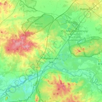
Name: Haltern am See topographic map, elevation, terrain.
Average elevation: 64 m
Minimum elevation: 25 m
Maximum elevation: 151 m
De gemeente ligt aan de -alleen voor kleine plezierboten, kano's e.d. bevaarbare Lippe. Parallel hieraan loopt het WDK. Ter hoogte van Flaesheim ligt een sluis in dit kanaal, en 2 klm verder oostwaarts een grote jachthaven.