
Luckau topographic map
Interactive map
Click on the map to display elevation.
About this map
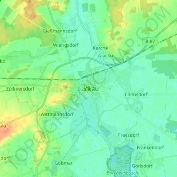
Name: Luckau topographic map, elevation, terrain.
Location: Luckau, Dahme-Spreewald, Brandenburg, 15926, Deutschland (51.81242 13.67501 51.89242 13.75501)
Average elevation: 67 m
Minimum elevation: 56 m
Maximum elevation: 92 m
Other topographic maps
Click on a map to view its topography, its elevation and its terrain.
Zieckau
Deutschland > Brandenburg > Dahme-Spreewald > Luckau
Zieckau, Luckau, Dahme-Spreewald, Brandenburg, Deutschland
Average elevation: 71 m