
Thank you for supporting this site ❤️
Make a donation
Make a donation
Duenweg topographic map
Click on the map to display elevation.
Thank you for supporting this site ❤️
Make a donation
Make a donation
About this map
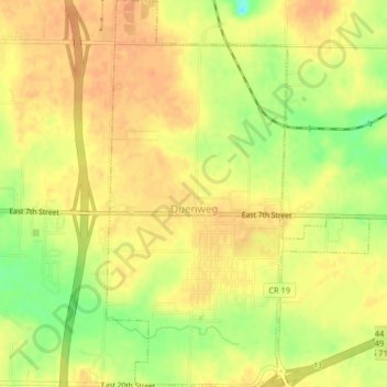
Name: Duenweg topographic map, elevation, terrain.
Location: Duenweg, Jasper County, Missouri, 64841, United States (37.06868 -94.42286 37.10119 -94.39510)
Average elevation: 323 m
Minimum elevation: 296 m
Maximum elevation: 336 m
Thank you for supporting this site ❤️
Make a donation
Make a donation
Other topographic maps
Click on a map to view its topography, its elevation and its terrain.