
Thank you for supporting this site ❤️
Make a donation
Make a donation
Brancaster Staithe topographic map
Click on the map to display elevation.
Thank you for supporting this site ❤️
Make a donation
Make a donation
About this map
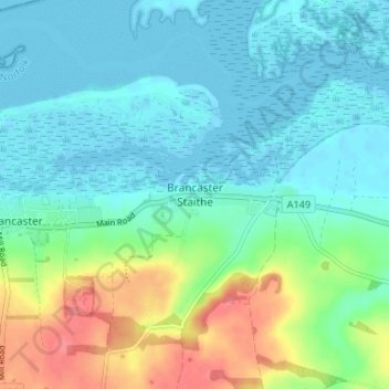
Name: Brancaster Staithe topographic map, elevation, terrain.
Average elevation: 18 m
Minimum elevation: -1 m
Maximum elevation: 69 m
Thank you for supporting this site ❤️
Make a donation
Make a donation
Other topographic maps
Click on a map to view its topography, its elevation and its terrain.
Terrington St. Clement
United Kingdom > England > Norfolk > King's Lynn and West Norfolk
Average elevation: 2 m
Downham Market
United Kingdom > England > Norfolk > King's Lynn and West Norfolk
Average elevation: 20 m
Thank you for supporting this site ❤️
Make a donation
Make a donation
Burn
United Kingdom > England > Norfolk > King's Lynn and West Norfolk > Burnham Overy
Average elevation: 16 m
Thank you for supporting this site ❤️
Make a donation
Make a donation
Burnham Market
United Kingdom > England > Norfolk > King's Lynn and West Norfolk
Average elevation: 44 m