
Urft topographic map
Interactive map
Click on the map to display elevation.
About this map
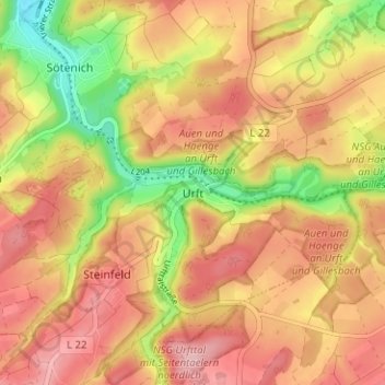
Name: Urft topographic map, elevation, terrain.
Average elevation: 475 m
Minimum elevation: 376 m
Maximum elevation: 541 m
Other topographic maps
Click on a map to view its topography, its elevation and its terrain.
Wahlen
Duitsland > Noordrijn-Westfalen > Kreis Euskirchen > Kall
Wahlen, Kall, Kreis Euskirchen, Noordrijn-Westfalen, 53925, Duitsland
Average elevation: 528 m
Scheven
Duitsland > Noordrijn-Westfalen > Kreis Euskirchen > Kall
Scheven, Kall, Kreis Euskirchen, Noordrijn-Westfalen, 53925, Duitsland
Average elevation: 399 m