
Thank you for supporting this site ❤️
Make a donation
Make a donation
Weifang topographic map
Click on the map to display elevation.
Thank you for supporting this site ❤️
Make a donation
Make a donation
About this map
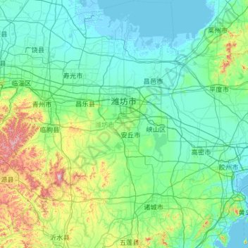
Name: Weifang topographic map, elevation, terrain.
Location: Weifang, Shandong, China (35.71638 118.17028 37.37234 120.01012)
Average elevation: 101 m
Minimum elevation: -3 m
Maximum elevation: 964 m
Thank you for supporting this site ❤️
Make a donation
Make a donation
Other topographic maps
Click on a map to view its topography, its elevation and its terrain.