
Make a donation
Fire River topographic map
Click on the map to display elevation.
Make a donation
About this map
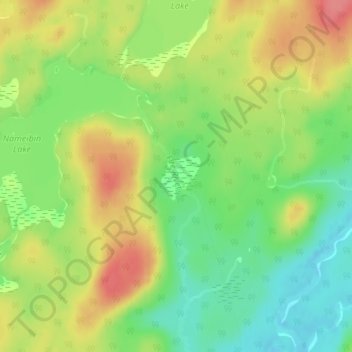
Name: Fire River topographic map, elevation, terrain.
Average elevation: 399 m
Minimum elevation: 364 m
Maximum elevation: 437 m
Make a donation
Other topographic maps
Click on a map to view its topography, its elevation and its terrain.
Make a donation
Make a donation
Kabinakagami Lake
Canada > Ontario > Algoma District > Unorganized North Algoma
Average elevation: 332 m
Make a donation
Make a donation
Kimiwan Creek;Kimiwan Lakes
Canada > Ontario > Algoma District > Unorganized North Algoma
Average elevation: 442 m
Make a donation
Ogidaki Mountain
Canada > Ontario > Algoma District > Unorganized North Algoma
Average elevation: 556 m
Make a donation
Montreal River Harbour
Canada > Ontario > Algoma District > Unorganized North Algoma
Average elevation: 212 m
Make a donation
Kabinakagamisis Lake
Canada > Ontario > Algoma District > Unorganized North Algoma
Average elevation: 324 m
Make a donation
Dog Lake Narrows
Canada > Ontario > Algoma District > Unorganized North Algoma > Missanabie
Average elevation: 335 m
Alligator Point
Canada > Ontario > Algoma District > Unorganized North Algoma
Average elevation: 319 m
Make a donation