
Vazhikadavu topographic map
Interactive map
Click on the map to display elevation.
About this map
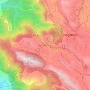
Name: Vazhikadavu topographic map, elevation, terrain.
Location: Vazhikadavu, Meenachil, Kottayam, Kerala, 685503, India (9.66402 76.87531 9.70402 76.91531)
Average elevation: 882 m
Minimum elevation: 279 m
Maximum elevation: 1,190 m
Other topographic maps
Click on a map to view its topography, its elevation and its terrain.
Kurishumala
India > Kerala > Vazhikadavu
Kurishumala, Vazhikadavu, Kottayam, Kerala, India
Average elevation: 862 m