
Cornwall (Connecticut) topographic map
Interactive map
Click on the map to display elevation.
About this map
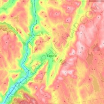
Name: Cornwall (Connecticut) topographic map, elevation, terrain.
Average elevation: 344 m
Minimum elevation: 122 m
Maximum elevation: 506 m
Other topographic maps
Click on a map to view its topography, its elevation and its terrain.
Corner of the Pines
États-Unis d'Amérique > Connecticut > Litchfield County > Cornwall (Connecticut) > Corner of the Pines
Corner of the Pines, Cornwall (Connecticut), Litchfield County, Connecticut, 06753, États-Unis d'Amérique
Average elevation: 304 m
New Milford
États-Unis d'Amérique > Connecticut > Litchfield County > New Milford
New Milford, Litchfield County, Connecticut, États-Unis d'Amérique
Average elevation: 193 m