
Delta topographic map
Click on the map to display elevation.
Delta
Delta experiences a cold semi-arid climate (Köppen BSk) with hot summers and cold winters. Because of Delta's altitude and aridity, temperatures drop quickly after sunset, especially in the summer. Winters are cold. Daytime highs in the winter are usually above freezing, but nighttime lows drop well below freezing, occasionally falling below 0 °F or −17.8 °C. Delta's climate is similar to that of Salt Lake City, but much more arid.
About this map
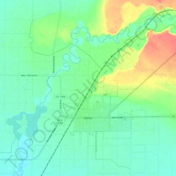
Name: Delta topographic map, elevation, terrain.
Location: Delta, Millard County, Utah, United States (39.33856 -112.61453 39.39694 -112.49604)
Average elevation: 1,417 m
Minimum elevation: 1,401 m
Maximum elevation: 1,453 m
Other topographic maps
Click on a map to view its topography, its elevation and its terrain.