
Grez-Doiceau topographic map
Interactive map
Click on the map to display elevation.
About this map
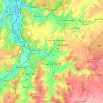
Name: Grez-Doiceau topographic map, elevation, terrain.
Average elevation: 81 m
Minimum elevation: 23 m
Maximum elevation: 145 m
Other topographic maps
Click on a map to view its topography, its elevation and its terrain.
Neu-Löwen
Belgien > Wallonisch-Brabant > Nivelles
Neu-Löwen, Ottignies-Louvain-la-Neuve, Nivelles, Wallonisch-Brabant, Wallonien, 1348, Belgien
Average elevation: 123 m
Waterloo
Belgien > Wallonisch-Brabant > Nivelles > Waterloo
Waterloo, Nivelles, Wallonisch-Brabant, Wallonien, 1410, Belgien
Average elevation: 112 m
Beauvechain
Belgien > Wallonisch-Brabant > Nivelles
Beauvechain, Nivelles, Wallonisch-Brabant, Wallonien, 1320, Belgien
Average elevation: 93 m