
Barnim topographic map
Interactive map
Click on the map to display elevation.
About this map
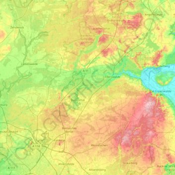
Name: Barnim topographic map, elevation, terrain.
Location: Barnim, Brandenburg, Deutschland (52.54557 13.39528 53.05868 14.15664)
Average elevation: 62 m
Minimum elevation: -1 m
Maximum elevation: 156 m
Der Landkreis Barnim ist ein Landkreis im Bundesland Brandenburg. Er ist benannt nach dem pleistozänen Höhenzug Barnim zwischen dem Eberswalder und dem Berliner Urstromtal. Die Kreisstadt ist Eberswalde.
Other topographic maps
Click on a map to view its topography, its elevation and its terrain.
Bernau
Deutschland > Brandenburg > Barnim
Bernau, Barnim, Brandenburg, 16321, Deutschland
Average elevation: 72 m
Eberswalde
Deutschland > Brandenburg > Barnim
Eberswalde, Barnim, Brandenburg, Deutschland
Average elevation: 53 m