
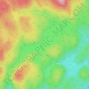
Lac McGrey topographic map
Interactive map
Click on the map to display elevation.
About this map
Name: Lac McGrey topographic map, elevation, terrain.
Location: Lac McGrey, Mandeville, D'Autray, Lanaudière, Québec, Canada (46.42379 -73.31284 46.43690 -73.28740)
Average elevation: 346 m
Minimum elevation: 255 m
Maximum elevation: 456 m
Other topographic maps
Click on a map to view its topography, its elevation and its terrain.
Lac Long
Canada > Québec > D'Autray > Mandeville
Lac Long, Mandeville, D'Autray, Lanaudière, Québec, Canada
Average elevation: 251 m
Lac des Chevreaux
Canada > Québec > D'Autray > Mandeville
Lac des Chevreaux, Mandeville, D'Autray, Lanaudière, Québec, Canada
Average elevation: 462 m
Lac aux Bouleaux
Canada > Québec > D'Autray > Mandeville
Lac aux Bouleaux, Mandeville, D'Autray, Lanaudière, Québec, Canada
Average elevation: 377 m
Lac Mandeville
Canada > Québec > D'Autray > Mandeville
Lac Mandeville, Mandeville, D'Autray, Lanaudière, Québec, Canada
Average elevation: 173 m
Lac Edward
Canada > Québec > D'Autray > Mandeville
Lac Edward, Mandeville, D'Autray, Lanaudière, Québec, Canada
Average elevation: 374 m
Rivière Mandeville
Canada > Québec > D'Autray > Mandeville > Saint-Charles-de-Mandeville
Rivière Mandeville, Saint-Charles-de-Mandeville, Mandeville, D'Autray, Lanaudière, Québec, Canada
Average elevation: 229 m
Saint-Charles-de-Mandeville
Canada > Québec > D'Autray > Mandeville
Saint-Charles-de-Mandeville, Mandeville, D'Autray, Lanaudière, Québec, J0K 1L0, Canada
Average elevation: 167 m