
Arkalgud topographic map
Click on the map to display elevation.
Arkalgud
Arkalgud is located at 12°46′N 76°04′E / 12.77°N 76.06°E / 12.77; 76.06. It has an average elevation of 918 m (3,012 ft). It lies partly in semi-malnad and partly in maidan tract. The total geographical area of the Taluk is 675 km2 (261 sq mi). It occupies sixth place in the District in terms of geographical area. The soil is red sandy derived from granites, gneiss and schists. The soil is red to brownish in colour, shallow to fairly deep shallow, loamy to sandy loamy in texture intermixed with fairly large amounts of coarse gravel and pebbles. They are well drained but poor in bases and water holding capacity. It is favourable for growing crops like paddy, sugarcane, coconut, potato, vegetables and plantation crops under irrigated conditions. It is suitable for growing ragi, millets, pulses, groundnut, potato and maize under rain-fed conditions. The river Kaveri enters at Kodavinahosahalli, a village in the south of Arkalgud and flows only through a small portion of about 24 km and enters Mysore district. An Anicut called Krishnarajakatte has been constructed across the river in the Taluk from which two channels viz. Kattepura channel and Ramanathapura channel take off for a length of about 24 km and 30 km respectively. The Kattepura channel runs along the south bank, past Rudrapatna; and the Ramanathapura Channel along the north bank past Konnanur and Ramanathapura to Basavapatna. The river Hemavati divides Arakalgud and Hassan taluks. The river enters in Honnathapura in the western side and flows towards to east and enters Holenarasipura taluk. The taluk receives rainfall from south-west monsoon. It is located at around 3,085 feet (940 m) above sea level. This taluk enjoys dry and cold climate during the year as the central part of the Taluk borders the Malenadu region and south-eastern portions form the southern maidan region. One can find some low hilly regions in the taluk as well as high altitude region such as Hippi-betta (3486 ft. or 1063 meters) in the western portion of the taluk. Konanur is the largest village in the taluk Basavapatna is one of the other village of Arakalgud taluk and Lakshmikanthaswamy temple is situated and Ramanathapura temples are famous in the same taluk every year one month jatra will be celebrated here.
About this map
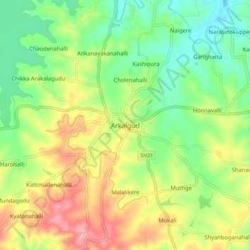
Name: Arkalgud topographic map, elevation, terrain.
Location: Arkalgud, Arakalagudu taluk, Hassan, Karnataka, 573102, India (12.72278 76.02234 12.80278 76.10234)
Average elevation: 911 m
Minimum elevation: 860 m
Maximum elevation: 982 m