
Dangam topographic map
Interactive map
Click on the map to display elevation.
About this map
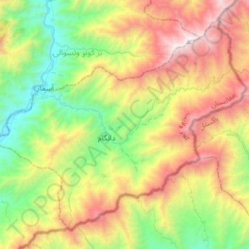
Name: Dangam topographic map, elevation, terrain.
Location: Dangam, Kunar Province, Afghanistan (34.91650 71.31014 35.08840 71.55860)
Average elevation: 1,972 m
Minimum elevation: 872 m
Maximum elevation: 3,683 m
The population of Dangam is approximately 18,803 (2019). Of this, around 98% are Pashtuns and the remaining 2% are Tajiks. There are 50 sub-villages and the district center is Dangam (34°59′33″N 71°25′08″E / 34.9925°N 71.4189°E / 34.9925; 71.4189) at 1356 m altitude, located in the central part of the district.
Other topographic maps
Click on a map to view its topography, its elevation and its terrain.
Ghaziabad
Ghaziabad, Kunar Province, Afghanistan
Average elevation: 2,472 m