
Thank you for supporting this site ❤️
Make a donation
Make a donation
Crotone topographic map
Click on the map to display elevation.
Thank you for supporting this site ❤️
Make a donation
Make a donation
About this map
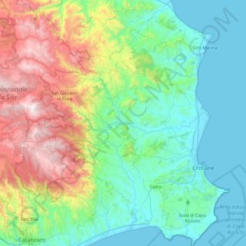
Name: Crotone topographic map, elevation, terrain.
Location: Crotone, Calabria, Italy (38.89247 16.61302 39.48244 17.20643)
Average elevation: 456 m
Minimum elevation: -1 m
Maximum elevation: 1,854 m
Thank you for supporting this site ❤️
Make a donation
Make a donation
Other topographic maps
Click on a map to view its topography, its elevation and its terrain.
Sant'Antonio
Italy > Calabria > Crotone > Isola di Capo Rizzuto > Sant'Antonio
Average elevation: 22 m