
Karak topographic map
Click on the map to display elevation.
Karak
The land of Karak Governorate is situated along the south eastern coast of the Dead Sea and the mountain chain known as the Mountains of Moab. Wadi Mujib, biblically known as Arnon River, flows through the mountains of Karak Governorate and ends in the Dead Sea. The cities in the governorate are located at elevations ranging from over 1000 meters above sea level in the South Mazar Department to 800 meters above sea level in the northern departments to about 330 meters below sea level at Ghor Al-Safi Department. The governorate is connected to the rest of Jordan by two highways.
About this map
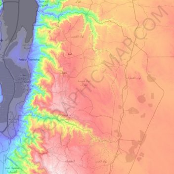
Name: Karak topographic map, elevation, terrain.
Location: Karak, Jordan (30.78899 35.32986 31.45760 36.21847)
Average elevation: 612 m
Minimum elevation: -415 m
Maximum elevation: 1,518 m
Other topographic maps
Click on a map to view its topography, its elevation and its terrain.
Zarqa
Jordan > Zarqa > Zarqa Sub-District
Zarqa has a cold semi-arid climate (Köppen climate classification: BSk). The average annual temperature is 17.4 °C (63.3 °F), and around 182 mm (7.17 in) of precipitation falls annually, mostly in winter months. Zarqa's elevation is 619 meters above sea level, and the city occasionally receives snowfall in…
Average elevation: 617 m