
Thank you for supporting this site ❤️
Make a donation
Make a donation
Samarqand Region topographic map
Click on the map to display elevation.
Thank you for supporting this site ❤️
Make a donation
Make a donation
About this map
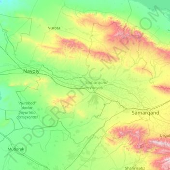
Name: Samarqand Region topographic map, elevation, terrain.
Location: Samarqand Region, 140000, Uzbekistan (39.27710 65.11770 40.62213 67.53534)
Average elevation: 594 m
Minimum elevation: 166 m
Maximum elevation: 2,572 m
Thank you for supporting this site ❤️
Make a donation
Make a donation
Other topographic maps
Click on a map to view its topography, its elevation and its terrain.
Thank you for supporting this site ❤️
Make a donation
Make a donation
Thank you for supporting this site ❤️
Make a donation
Make a donation
Jizzax
From the slopes of the mountains at an altitude of 1800 meters above sea level, pine forests begin. As the mountains rise, the pine forest thickens.
Average elevation: 381 m
Thank you for supporting this site ❤️
Make a donation
Make a donation