
Arequipa topographic map
Click on the map to display elevation.
Arequipa
This department has a rough topography, which is characterised by heavy layers of volcanic lava covering large areas of its inter-Andean sector. It has deep canyons such as the ones formed by the Ocoña and Majes rivers. Plateaus range in height from medium, such as La Joya, and high-altitude ones such the Arrieros Pampa and those located in the zones of Chivay, Huambo and Pichucolla. Volcanic cones, such as Misti, Chachani, Ampato, Mismi, Solimana and Coropuna, emerge above the plateaus and attract snowfall. In contrast with these heights, there are deep canyons, including Majes, Colca, Sihuas and Ocoña, where important aspects of the ecological evolution of this zone can be clearly observed.
About this map
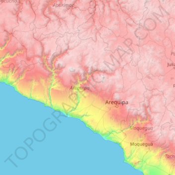
Name: Arequipa topographic map, elevation, terrain.
Location: Arequipa, Peru (-17.28501 -75.07199 -14.63274 -70.80408)
Average elevation: 2,599 m
Minimum elevation: 0 m
Maximum elevation: 6,195 m
Other topographic maps
Click on a map to view its topography, its elevation and its terrain.
Ausangate
Ausangate or Auzangate (in Hispanicized spellings) is a mountain of the Vilcanota mountain range in the Andes of Peru. With an elevation of 6,384 metres, it is situated around 100 kilometres southeast of Cusco in the Cusco Region, Canchis Province, Pitumarca District, and in the Quispicanchi Province, Ocongate…
Average elevation: 5,617 m
Cerro de Pasco
Peru > Pasco > Cerro de Pasco
Cerro de Pasco is a city in central Peru, located at the top of the Andean mountains. It is the capital of the Pasco region, and an important mining center. At 4,330 metres (14,210 ft) elevation, it is one of the highest cities in the world, and the highest or the second highest city with over 50,000…
Average elevation: 4,239 m