
Luchau topographic map
Interactive map
Click on the map to display elevation.
About this map
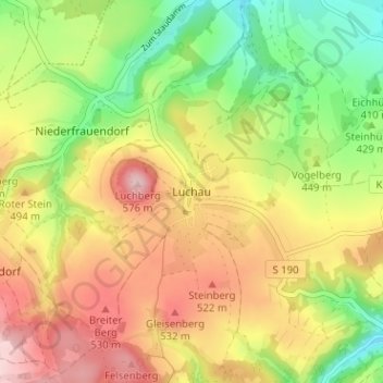
Name: Luchau topographic map, elevation, terrain.
Average elevation: 459 m
Minimum elevation: 349 m
Maximum elevation: 571 m
Other topographic maps
Click on a map to view its topography, its elevation and its terrain.
Oberfrauendorf
Deutschland > Sachsen > Sächsische Schweiz-Osterzgebirge > Glashütte
Oberfrauendorf, Glashütte, Sächsische Schweiz-Osterzgebirge, Sachsen, 01768, Deutschland
Average elevation: 504 m
Hausdorf
Deutschland > Sachsen > Sächsische Schweiz-Osterzgebirge > Glashütte > Hausdorf
Hausdorf, Glashütte, Sächsische Schweiz-Osterzgebirge, Sachsen, 01768, Deutschland
Average elevation: 332 m