
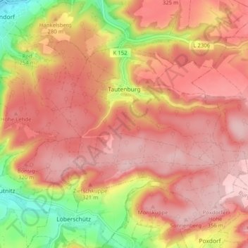
Tautenburg topographic map
Interactive map
Click on the map to display elevation.
About this map
Name: Tautenburg topographic map, elevation, terrain.
Average elevation: 279 m
Minimum elevation: 129 m
Maximum elevation: 359 m
Other topographic maps
Click on a map to view its topography, its elevation and its terrain.
Kämmelberg
Duitsland > Thüringen > Saale-Holzland-Kreis > Altenberga
Kämmelberg, Altenberga, Südliches Saaletal, Saale-Holzland-Kreis, Thüringen, Duitsland
Average elevation: 309 m
Mörsdorf
Duitsland > Thüringen > Saale-Holzland-Kreis > Mörsdorf
Mörsdorf, Hermsdorf, Saale-Holzland-Kreis, Thüringen, Duitsland
Average elevation: 330 m