
Make a donation
Guayas topographic map
Click on the map to display elevation.
Make a donation
Guayas
Guayas' natural terrain is very diverse. The province has no elevations, except for the Coastal Range, which starts in Guayaquil and goes to Manabí. The areas west of the Coastal Range are desertic, with an average temperature of 23 °C. The areas east of the range belong to the Guayas Watershed. They are quite humid and fertile, especially in the north of the province, with an average temperature of 30 °C in the humid season (December–May) and 25 °C in the dry season (June–November).
Make a donation
About this map
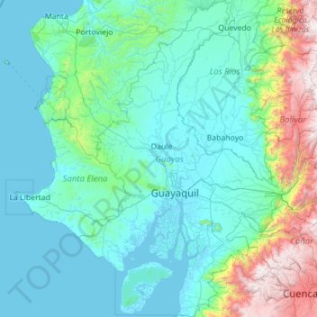
Name: Guayas topographic map, elevation, terrain.
Location: Guayas, Ecuador (-3.06426 -80.56330 -0.83665 -79.09809)
Average elevation: 519 m
Minimum elevation: -3 m
Maximum elevation: 4,464 m
Make a donation
Other topographic maps
Click on a map to view its topography, its elevation and its terrain.
Quito
Ecuador > Pichincha > Quito Canton
Quito's elevation of 2,850 m (9,350 ft) makes it either the highest or the second highest capital city in the world. This varied standing is because Bolivia is a country with multiple capitals; if La Paz is considered the Bolivian national capital, it tops the list of highest capitals, but if Sucre is…
Average elevation: 2,930 m
Make a donation
Make a donation