
Ben Guerdane topographic map
Interactive map
Click on the map to display elevation.
About this map
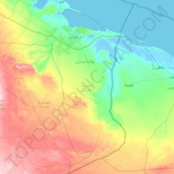
Name: Ben Guerdane topographic map, elevation, terrain.
Location: Ben Guerdane, Médenine, 4160, Tunisie (32.24992 10.52354 33.37434 11.59994)
Average elevation: 67 m
Minimum elevation: -5 m
Maximum elevation: 234 m
Other topographic maps
Click on a map to view its topography, its elevation and its terrain.
El Mahboubine
El Mahboubine, Djerba Midoun, Médenine, 4165, Tunisie
Average elevation: 21 m
Parc National Sidi Toui
Parc National Sidi Toui, El Amria, Ben Guerdane, Médenine, Tunisie
Average elevation: 104 m