
Nuevo Celendín topographic map
Interactive map
Click on the map to display elevation.
About this map
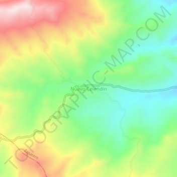
Name: Nuevo Celendín topographic map, elevation, terrain.
Location: Nuevo Celendín, Zapatero, Lamas, San Martín, Perú (-6.60587 -76.55194 -6.56587 -76.51194)
Average elevation: 829 m
Minimum elevation: 629 m
Maximum elevation: 1,114 m
Other topographic maps
Click on a map to view its topography, its elevation and its terrain.
Huicungo
Huicungo, Mariscal Cáceres, San Martín, 15169, Perú
Average elevation: 1,312 m
Nueva Alianza
Perú > San Martín > Moyobamba
Nueva Alianza, Moyobamba, San Martín, Perú
Average elevation: 881 m
San José de Sisa
Perú > San Martín > San José de Sisa
San José de Sisa, El Dorado, San Martín, Perú
Average elevation: 688 m
Río Huallaga
Río Huallaga, Mariscal Cáceres, San Martín, 10003, Perú
Average elevation: 1,253 m