
Thank you for supporting this site ❤️
Make a donation
Make a donation
Hadleigh topographic map
Click on the map to display elevation.
Thank you for supporting this site ❤️
Make a donation
Make a donation
About this map
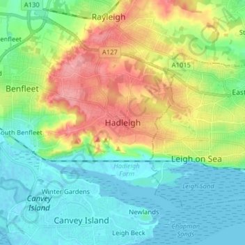
Name: Hadleigh topographic map, elevation, terrain.
Location: Hadleigh, Castle Point, Essex, England, SS7 2RD, United Kingdom (51.51392 0.56870 51.59392 0.64870)
Average elevation: 29 m
Minimum elevation: -1 m
Maximum elevation: 87 m
Thank you for supporting this site ❤️
Make a donation
Make a donation