
Bledsoe County topographic map
Interactive map
Click on the map to display elevation.
About this map
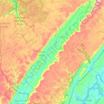
Name: Bledsoe County topographic map, elevation, terrain.
Location: Bledsoe County, Tennessee, 37367, United States of America (35.35321 -85.43364 35.77362 -84.90521)
Average elevation: 467 m
Minimum elevation: 200 m
Maximum elevation: 883 m
Other topographic maps
Click on a map to view its topography, its elevation and its terrain.
Dickson County
United States of America > Tennessee
Dickson County, Tennessee, United States of America
Average elevation: 211 m
Englewood
United States of America > Tennessee > Englewood
Englewood, Washington County, Tennessee, 37615:37659, United States of America
Average elevation: 472 m
Gatlinburg
United States of America > Tennessee > Gatlinburg > Gatlinburg
Gatlinburg, Sevier County, Tennessee, United States of America
Average elevation: 577 m