
Stenungsunds kommun topographic map
Interactive map
Click on the map to display elevation.
About this map
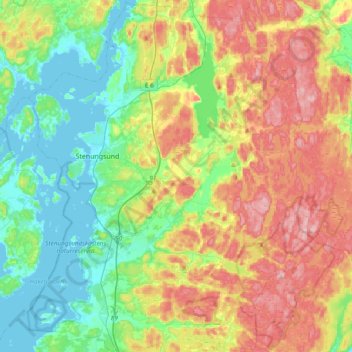
Name: Stenungsunds kommun topographic map, elevation, terrain.
Average elevation: 69 m
Minimum elevation: -1 m
Maximum elevation: 177 m
Other topographic maps
Click on a map to view its topography, its elevation and its terrain.
Gothenburg
Sweden > Västra Götaland County > Gothenburg
Gothenburg, Göteborgs Stad, Västra Götaland County, Region Götaland, 41106, Sweden
Average elevation: 45 m
Broke
Sweden > Västra Götaland County
Broke, Tjörns kommun, Västra Götaland County, Region Götaland, Sweden
Average elevation: 0 m
Gäven
Sweden > Västra Götaland County
Gäven, Lysekils kommun, Västra Götaland County, Region Götaland, Sweden
Average elevation: 0 m
Brännö
Sweden > Västra Götaland County > Gothenburg
Brännö, Gothenburg, Göteborgs Stad, Västra Götaland County, Region Götaland, 43085, Sweden
Average elevation: 6 m
Ulricehamns kommun
Sweden > Västra Götaland County
Ulricehamns kommun, Västra Götaland County, Region Götaland, Sweden
Average elevation: 247 m
Borås
Sweden > Västra Götaland County > Borås
Borås, Västra Götaland County, Region Götaland, 50310, Sweden
Average elevation: 192 m
Kinnekulle
Sweden > Västra Götaland County > Skogslund
Kinnekulle, O 2722, Österplana distrikt, Skogslund, Götene, Västra Götaland County, Region Götaland, 533 94, Sweden
Average elevation: 133 m