
County Dublin topographic map
Click on the map to display elevation.
County Dublin
Dublin is a topographically varied region. The city centre is generally very low-lying, and many areas of coastal Dublin are at or near sea-level. In the south of the county, the topography rises steeply from sea-level at the coast to over 500 metres (1,600 ft) in just a few kilometres. This natural barrier has resulted in densely populated coastal settlements in Dún Laoghaire–Rathdown and westward urban sprawl in South Dublin. In contrast, Fingal is generally rural in nature and much less densely populated than the rest of the county. Consequently, Fingal is significantly larger than the other three local authorities and covers about 49.5% of County Dublin's land area. Fingal is also perhaps the flattest region in Ireland, with the low-lying Naul Hills rising to a maximum height of just 176 metres (577 ft).
About this map
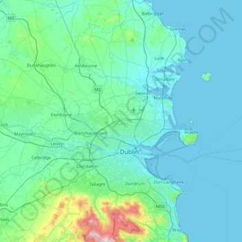
Name: County Dublin topographic map, elevation, terrain.
Location: County Dublin, Leinster, Ireland (53.17826 -6.54689 53.63471 -5.99450)
Average elevation: 71 m
Minimum elevation: -1 m
Maximum elevation: 733 m
Other topographic maps
Click on a map to view its topography, its elevation and its terrain.
Morning Star
Ireland > County Limerick > The Municipal District of Cappamore — Kilmallock
Average elevation: 46 m
Limerick
Ireland > County Limerick > Limerick
Limerick's climate is classified as temperate oceanic (Köppen Cfb). Met Éireann maintains a climatological weather station at Shannon Airport, 20 kilometres west of the city in County Clare. Shannon Airport records an average of 977 millimetres of precipitation annually, most of which is rain. Limerick has a…
Average elevation: 10 m