
Xiapitou topographic map
Interactive map
Click on the map to display elevation.
About this map
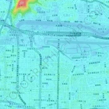
Name: Xiapitou topographic map, elevation, terrain.
Location: Xiapitou, Taipei, 10476, Taiwan (25.04516 121.52267 25.08516 121.56267)
Average elevation: 12 m
Minimum elevation: -9 m
Maximum elevation: 137 m
Other topographic maps
Click on a map to view its topography, its elevation and its terrain.
Xinyi Commercial Zone
Xinyi Commercial Zone, Taipei, 110, Taiwan
Average elevation: 38 m
Shipai Village
Shipai Village, Beitou, Lanya, Taipei, Taiwan
Average elevation: 14 m
Songshan District
Songshan District, Tanmei, Taipei, Taiwan
Average elevation: 13 m
Guangfu Village
Taiwan > Taipei > Taipei > Chengnei
Guangfu Village, Chengnei, Taipei, Zhongzheng District, 10045, Taiwan
Average elevation: 12 m