
Lac Kyoga topographic map
Interactive map
Click on the map to display elevation.
About this map
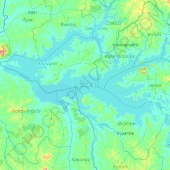
Name: Lac Kyoga topographic map, elevation, terrain.
Location: Lac Kyoga, Amolatar, Northern Region, Ouganda (1.19160 32.34135 1.79367 33.48573)
Average elevation: 1,056 m
Minimum elevation: 1,030 m
Maximum elevation: 1,375 m
Other topographic maps
Click on a map to view its topography, its elevation and its terrain.
Lake Kwania
Lake Kwania, Apeneki, Amolatar, Northern Region, Ouganda
Average elevation: 1,062 m