
Red Feather Lakes topographic map
Interactive map
Click on the map to display elevation.
About this map
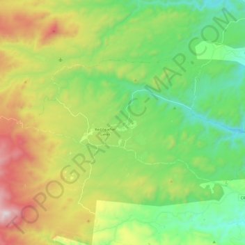
Name: Red Feather Lakes topographic map, elevation, terrain.
Average elevation: 2,551 m
Minimum elevation: 2,137 m
Maximum elevation: 3,314 m
Red Feather Lakes is located in north-central Larimer County at 40°48′28″N 105°34′43″W / 40.80778°N 105.57861°W / 40.80778; -105.57861 (40.807820, -105.578641), at an elevation of 8,100 to 8,500 feet (2,500 to 2,600 m). Via Red Feather Lakes Road, it is 24 miles (39 km) west of U.S. Route 287 at Livermore and 45 miles (72 km) northwest of Fort Collins, the county seat.