
Meckel topographic map
Interactive map
Click on the map to display elevation.
About this map
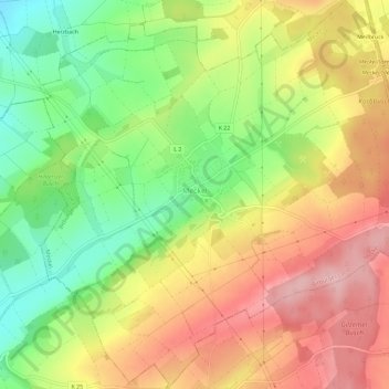
Name: Meckel topographic map, elevation, terrain.
Average elevation: 337 m
Minimum elevation: 249 m
Maximum elevation: 421 m
Meckel liegt in der Südwesteifel, etwa 10 km südlich des Zentrums der Kreisstadt Bitburg. Das Gemeindegebiet erstreckt sich in einer Talmulde und wird am östlichen Rand von der Bundesstraße 51 tangiert. Die Höhenlage reicht von etwa 270 m ü. NHN bis 396 m ü. NHN (Meckeler Höhe). Durch den Ort fließt der Nüßbach, ein linker Zufluss der Nims. Zu Meckel gehört auch der Wohnplatz Meilbrück.
Other topographic maps
Click on a map to view its topography, its elevation and its terrain.
Hüttingen an der Kyll
Deutschland > Rheinland-Pfalz > Eifelkreis Bitburg-Prüm
Hüttingen an der Kyll, Bitburger Land, Eifelkreis Bitburg-Prüm, Rheinland-Pfalz, Deutschland
Average elevation: 296 m
Wallendorf
Deutschland > Rheinland-Pfalz > Eifelkreis Bitburg-Prüm
Wallendorf, Südeifel, Eifelkreis Bitburg-Prüm, Rheinland-Pfalz, Deutschland
Average elevation: 296 m
Daleiden
Deutschland > Rheinland-Pfalz > Eifelkreis Bitburg-Prüm
Daleiden, Arzfeld, Eifelkreis Bitburg-Prüm, Rheinland-Pfalz, 54689, Deutschland
Average elevation: 431 m
Ferschweiler
Deutschland > Rheinland-Pfalz > Eifelkreis Bitburg-Prüm
Ferschweiler, Südeifel, Eifelkreis Bitburg-Prüm, Rheinland-Pfalz, Deutschland
Average elevation: 346 m
Manderscheid
Deutschland > Rheinland-Pfalz > Eifelkreis Bitburg-Prüm
Manderscheid, Arzfeld, Eifelkreis Bitburg-Prüm, Rheinland-Pfalz, Deutschland
Average elevation: 433 m
Rodershausen
Deutschland > Rheinland-Pfalz > Eifelkreis Bitburg-Prüm > Rodershausen
Rodershausen, Südeifel, Eifelkreis Bitburg-Prüm, Rheinland-Pfalz, Deutschland
Average elevation: 443 m