
Make a donation
Alford topographic map
Click on the map to display elevation.
Make a donation
About this map
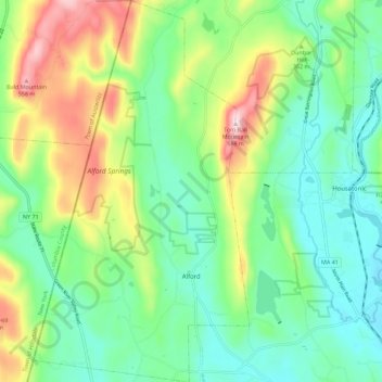
Name: Alford topographic map, elevation, terrain.
Location: Alford, Berkshire County, Massachusetts, United States (42.21272 -73.46009 42.29617 -73.39624)
Average elevation: 329 m
Minimum elevation: 210 m
Maximum elevation: 581 m
Make a donation
Other topographic maps
Click on a map to view its topography, its elevation and its terrain.
Taconic Mountain Wildlife Management Area
United States > Massachusetts > Berkshire County > Williamstown
Average elevation: 608 m
Lake Averic
United States > Massachusetts > Berkshire County > Stockbridge > Interlaken
Average elevation: 326 m
Make a donation
Berkshire South
United States > Massachusetts > Berkshire County > Great Barrington
Average elevation: 266 m
Make a donation
Root Orchards
United States > Massachusetts > Berkshire County > Great Barrington > Housatonic > Risingdale
Average elevation: 278 m
Natural Bridge State Park
United States > Massachusetts > Berkshire County > North Adams
Average elevation: 318 m
Make a donation
West New Boston
United States > Massachusetts > Berkshire County > Sandisfield
Average elevation: 356 m
Make a donation
Indian Lake Association
United States > Massachusetts > Berkshire County > Becket
Average elevation: 455 m
Tyringham Cobble
United States > Massachusetts > Berkshire County > Tyringham
Average elevation: 348 m
Beachwood
United States > Massachusetts > Berkshire County > Stockbridge > Beachwood
Average elevation: 317 m
Make a donation
North Adams
United States > Massachusetts > Berkshire County > North Adams > North Adams
Average elevation: 415 m
Make a donation