
Make a donation
Sandwich topographic map
Click on the map to display elevation.
Make a donation
Sandwich
The White Mountain National Forest occupies the northwestern quadrant of the town, as well as a strip of land along the town's northern border. Mount Israel, elevation 2,630 feet (802 m) above sea level, is within the national forest close to the geographic center of the town. Part of the Squam Mountains is in the west. Part of the Sandwich Range is in the north, including the 3,993-foot (1,217 m) Sandwich Mountain (also known as Sandwich Dome), the highest point in town as well as in Carroll County.
Make a donation
About this map
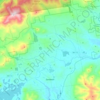
Name: Sandwich topographic map, elevation, terrain.
Average elevation: 381 m
Minimum elevation: 155 m
Maximum elevation: 1,200 m
Make a donation
Other topographic maps
Click on a map to view its topography, its elevation and its terrain.
Winnipesaukee
United States > New Hampshire > Carroll County > Moultonborough
Average elevation: 161 m
Make a donation
Make a donation
Little Bear Island
United States > New Hampshire > Carroll County > Tuftonboro
Average elevation: 160 m
Black Cat Island
United States > New Hampshire > Carroll County > Moultonborough
Average elevation: 156 m
Nineacre Island
United States > New Hampshire > Carroll County > Moultonborough
Average elevation: 158 m
Make a donation
Whortleberry Island
United States > New Hampshire > Carroll County > Tuftonboro > Chase Point
Average elevation: 156 m
Cow Island
United States > New Hampshire > Carroll County > Tuftonboro > Fox Point
Average elevation: 162 m
Make a donation
Make a donation
Mount Roberts
United States > New Hampshire > Carroll County > Moultonborough
Average elevation: 611 m
Winnipesaukee
United States > New Hampshire > Carroll County > Moultonborough
Average elevation: 161 m
Make a donation
Mirror Lake
United States > New Hampshire > Carroll County > Tuftonboro > Mirror Lake
Average elevation: 169 m
Whortleberry Island
United States > New Hampshire > Carroll County > Tuftonboro > Chase Point
Average elevation: 156 m
Albany
United States > New Hampshire > Carroll County > Albany
According to the United States Census Bureau, the town has a total area of 75.8 square miles (196.2 km2), of which 75.1 square miles (194.6 km2) are land and 0.58 square miles (1.5 km2) are water, comprising 0.79% of the town. It is drained by the Swift River in the north and the Chocorua River in the south.…
Average elevation: 276 m
Make a donation